

Tungnath Chandrashila Peak Trek
Duration: 2 Days / 1 Nights
---- Itinerary ----
Day 1: Drive Rishikesh-Sari
• The pick-up point for your upcoming journey is Rishikesh Bus Station.
• Please note that the pick-up time is scheduled for 6:00 am.
• The trekking distance is approximately 190 km and the estimated driving time is around 7 hours.
• The altitude at the destination is 6,600 feet.
• Network availability is available until Sari.
You will be picked up early from Rishikesh at 6:30 AM today. If you wish to arrive a few days before the trek start date, you can arrange an overnight bus ride from Delhi to reach Haridwar early in the morning. Haridwar-Rishikesh, located along the Ganges, is a popular spot on the pilgrimage trail of Uttarakhand. While in Rishikesh, you can participate in cultural activities and enjoy adventure sports in the Ganges river.
The drive from Rishikesh to Sari village takes 7-8 hours, during which you can admire the breathtaking views of the lower Garhwal Himalayas. The most beautiful and memorable point of interest along the route is Devaprayag. This town marks the stunning convergence of the Alakananda and Bhagirathi rivers. The river will be a constant companion; you will reach Sari around 6:00 to 6:30 PM. Sari is a picturesque village with tiny houses dotted on the mountainside and surrounded by lush agricultural fields. If you need any essential items for the trip, you can visit the market in Sari to purchase them.
Day 2: Trek to Deoriatal
• The trek distance for this particular trail is 3 kilometers.
• It usually takes around 1 hour to complete the trek depending on your pace and fitness level.
• The altitude of the trek is around 7,800 ft. above sea level, so it is recommended to take necessary precautions to avoid altitude sickness.
• There is no water source available along the trail, so it’s advisable to carry enough water to stay hydrated during the trek.
On the first day of the trek, you will hike up and down a rocky trail to reach the top, where you can see the Chandrashila summit and the Tunganath temple in the distance. From there, you’ll climb uphill along a steep ridge to reach a Forest Department resting stop. If you’re with the Trek Leader, you can take a 20-minute break here and enjoy the stunning view of the mountain’s fall. After resting, the trail will lead you through a rhododendron forest, where you’ll witness the vibrant shadow blooms of rhododendrons during the spring treks. You’ll continue climbing steadily until you reach 7,434 feet, and the villages disappear. After about 20 minutes, you’ll arrive at the lakes of Deoriatal, where you’ll get a magnificent view of the Chaukhamba mountains in the background. You’ll have time to explore the forest and its hidden nooks and crevices, making it an ideal spot for nature enthusiasts and bird watchers. Lunch will be served upon reaching the lakeside camp located in Deorital.
Day 03: By Trek From Deoriatal To Baniyakund Through Rohini Bugyal
• Trek distance: 16 kilometers
• Estimated time to complete: 7-8 hours
• Altitude at Chopta: 8,700 feet above sea level
• Ground source of water available just before entering Rohini Bugyal
• Waterfalls available on the second part of the route for refilling water bottles
Embark on today’s thrilling trek that will bring you closer to the majestic Chaukhamba mountain range and the awe-inspiring Mount Kedar summit. The forest trail, adorned with vibrant maples and rhododendrons, will invigorate your senses with its cool and refreshing ambience. As you venture deeper into the dense forests, you’ll encounter two distinct varieties of rhododendrons, pink and red, their abundance increasing with each step beyond the initial forest stretch.
The path is dotted with small shrines that are distinguished by yellow and red flags pinned to them. After crossing a clearing in the forest, which is full of scarlet blooms, you’ll be escorted uphill to Rohgini Bugyal and Chopta. The trail ascends to a level terrain and has some sway during the uphill climb. On the opposite side of the edge, you’ll be able to see a stunning view of Chandrashila. After the level land, you must enter the forest that is now dominated by old oaks, maples, and Rhododendrons. This is part of the Kedarnath Sanctuary, and with some luck, you may spot red foxes, Himalayan black bears, and other smaller wild creatures. The sanctuary is also home to a variety of bird species, including the Himalayan Monal, the state bird of Uttarakhand.
After another 25 minutes of walking along the Kedarnath Sanctuary trail, you’ll arrive at Bhagdwal temple, which is a junction point for three trekking routes. One route connects with Sari village, the other to Ukhimath, and the third one descends into the meadows of Rohini Bugyal. Along this path, Chandrashila and the adjacent Kala Parvat Peak gain prominence. The path through here bends towards Bisuri Tal Lake and the small tarn known as Nandikund located at the foot of Kala Parvat. In the further distance, as you travel along the river, a silvery rivulet flowing from Chandrashila comes into your path. This is where you can replenish your water reservoirs and continue to a wooden bridge over the river. Don’t forget to respect the local customs and traditions, such as removing your shoes before entering the temple
Just a little further, the meadows will begin, and there will be an array of shelters. Shepherds from villages in the area are here to feed their animals. Nearby is a road-head at the end of a jungle trail. In the area around Chopta village, we have our campsite at a clearing located in the forest. From here, you can choose to continue your trek to Sari village, which is a relatively easy route, or to Ukhimath, which is a more challenging route. Alternatively, you can descend into the meadows of Rohini Bugyal, which is a moderate route suitable for most trekkers.
Day 4: Baniyakund up to Tungnath, Chandrashilla Top and back to Baniyakund
• Buniyakund is the starting point of your journey that will take you to the beautiful Chopta region.
• The distance between Buniyakund and Chopta is just 3km, which you can cover by car.
• Once you reach Chopta, you will start your trek to Tungnath, Chandrashilla Summit and back.
• The entire trek is about 8km long, and it should take you around 7-8 hours to complete the round trip.
• As you ascend towards the summit, you will experience a gradual increase in altitude.
• The trek reaches an altitude of 13,100 ft at its highest point, which is the Chandrashilla Summit.
• While the trek is challenging, the stunning views make it all worth it.
• However, it’s important to note that there are no water sources along the trek, so it’s essential to carry enough water and stay hydrated throughout the journey.
We will embark on our trek early morning, while it’s still dark outside. Our route is well-defined and concrete-bound, leading from Chopta to the Tunganath shrine. Along the way, we’ll encounter a challenging climb with sharp turns, and we’ll pass by several noteworthy sites, including one with a flagpole, just after the 10th bend in the road. From here, you’ll be able to see the stunning Chandrashila peak to the right and another peak that connects to it, called Ravanshila.
During winter, there will be snow on the path, and it’s essential to be cautious of the thick snowfall on the summit from December to April. Snow climbing gear, such as gaiters and crampons, is recommended, and the trek leader might use an ice knife to guide the way through the snow sludge layer. The entrance to Tunganath is at the 11th bend, and the path to the Chandrashila peak starts within the temple compound.
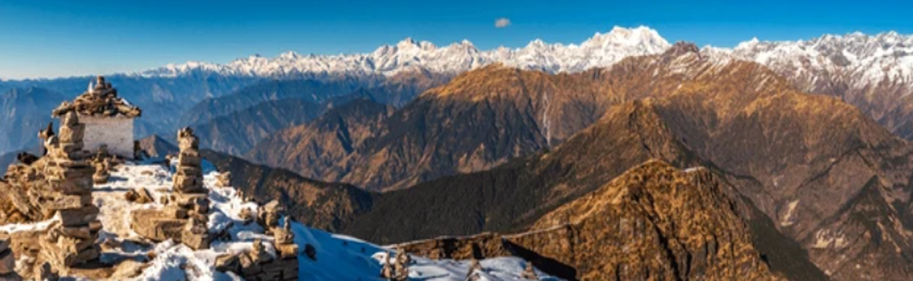
Once you reach the summit, after a steep and challenging uphill climb, you’ll be rewarded with a breathtaking 360-degree view of the Garhwal and Kumaon mountains. You’ll be able to see notable peaks such as Nanda Devi Trishul, Nandaghunti, Dronagiri, Chaukhamba, and Kedar, as well as glimpses of the Thalaysagar and Gangotri ranges from the edges.
The descent journey is more straightforward and less time-consuming, taking approximately 3 hours to reach the Baniyakund campsite.
Day 5: Baniyakund to Rishikesh
• Drop off Point: Rishikesh bus station
• Distance: 210 km
• Estimated Time: 7 hours
• Expected Arrival Time: Around 6:30 pm
• Please note that the arrival time may vary due to traffic and unforeseen delays during the journey.
On the fifth day of your trip, we will arrange your return journey from Chopta Road to Rishikesh. This seven-hour journey will take you through some of the most breathtaking and scenic hilly terrain, leaving you with sweet memories that will last a lifetime. You will arrive in Rishikesh at night, where you can explore the city or relax and unwind after your long journey. We highly recommend a night trip to Delhi from Rishikesh, as it is a great way to experience the city’s beauty at night and avoid the traffic during the day. Whether you choose to stay in Rishikesh or head straight to Delhi, we guarantee that this journey will be an unforgettable one that you will cherish forever.
Inclusions
1. Accommodation: Homestay and guest house along the trek on a sharing basis.
2. Meals: All vegetarian meals, including breakfast, lunch, dinner, and tea/coffee.
3. Guides: Experienced trek leader and local support staff (porters and cooking staff).
4. Permits: All necessary permits and entry fees for trekking in the Himalayas.
5. Transportation: Pickup and drop-off from Rishikesh/Kathgodam.
Exclusions
1. Personal expenses, including tips, snacks, and meals during road journey.
2. Insurance and medical expenses.
3. Porter services for personal luggage.
4. Any expenses due to unforeseen circumstances like landslides or weather delays.
All Rights Reserved 2025- 2026 @ Peakends on Weekends